 Consistent with the recommendation in our weekly Caloosahatchee & Estuary Condition Report, the U.S. Army Corps of Engineers last week held off on releasing water from Lake Okeechobee, with the surface of the lake approaching 15.5 feet above sea level.
Under the current Lake Okeechobee Regulation Schedule (LORS), the Army Corps tries to maintain the lake between 12.5 and 15.5 feet to maintain a healthy lake ecology, provide flood protection, and water supply to agriculture, urbanized areas, and natural systems like the Caloosahatchee and its estuary.
The surface of the lake is currently at 15.52 ft., according to the Army Corps.
Excess water is already flowing off the Caloosahatchee River watershed, the lands and creeks and streams that flow into the river and estuary.
Flows measured at the W.P. Franklin Lock and Dam have been above the harmful threshold for weeks now and for the past week flows averaged more than 3,080 cubic feet per second, according to Army Corps data.
Flows at this level fall within the ecological “harmful threshold” identified by scientists and water managers, the point at which damage starts to occur in the estuary.
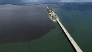
The Franklin Lock is the eastern edge of the brackish estuary, which extends west to Sanibel and Captiva Islands. Water released from Lake Okeechobee would compound the impacts of stormwater runoff from the Caloosahatchee watershed.
Not only would the extra freshwater flows further disrupt salinity conditions in the estuary, but releases could also deliver nutrients that can fuel harmful algal blooms within the estuary or along the Southwest Florida coast.
Barring any major storm or hurricane, the Lake Okeechobee level may soon stop rising as the rainy season typically ends in mid-October. Looking at water levels now and how much time is left in the rainy season, there may be just enough room left in Lake Okeechobee to make it through the next three weeks without releasing water to the estuaries.
That would certainly be a good thing for our river, estuary, and islands.
Click here to read full column. Click here to sign up for weekly Caloosahatchee & Estuary Condition Reports.
PHOTO CREDIT: Nick Adams Photography, Friday, Sept. 18.